|
|
All weekend, I geared up for the day's severe weather event. I had planned on traveling a couple hundred miles, though. That is nothing compared to how far some chasers travel. I was expecting the severe weather to be at the Iowa-Illinois border between Dubuque and the Quad Cities after storms started to pop by Cedar Rapids. Little did I know that my chase would start from my backyard. I figured that the storms would start to pop between 4:00 and 5:00 that afternoon, since that was when I thought the cap would break. I was hoping that the National Weather Service (NWS) would issue a tornado watch to confirm my thoughts. I figured that since the chase would be so close to home, I would be better off sitting at the computer where I could get more data. I was watching the KGAN radar page waiting for any sign that something was breaking the cap. I now understand why I have heard chasers say they get to involved in their computer and miss what is going on around them. While I was watching the radar on the net, which is updated every 15 minutes or less, I heard thunder. I ran and looked out the window and saw this monster thunderstorm going up to the west. I told Matt Salger, my chase partner, to grab the gear so we could get going. On the way out the door, the NWS issued the following warning: We drove south out of Vinton on Highway 218 to see this huge thunderstorm to our west. About one mile south of Vinton, we took the Garrison road so we were driving to the west into the storm. Since the storm was 9 miles west of Garrison moving to the east at 45 miles per hour, we felt we could get to Garrison and then move south of the storm so we could see the southwest corner of the storm. As the storm built, it expanded further west prompting this next warning:
As we approached the storm, it was incredible. I have never seen a storm like this in Iowa before. This was a huge supercell thunderstorm. It was about 2 to 3 times larger than any Iowa storm I had seen before. This looked like something that I had seen in Kansas and Nebraska before. The storm was over one county wide. That is why they issued a 3rd warning.
We made it to Garrison and took the paved road south before the storm got there. Matt and I drove south about 3 miles when we felt we were clear of the storm's path. It was now to our north and we were on the back end of it. The motion in this storm was incredible!!! Usually in Iowa you have to really look hard to see motion in the clouds. Today, unless you were totally blind, you could see the motion. The power and turbulence you could see was breath-taking. Little did we know that a 2nd storm was developing behind this one. After driving parallel to the storm for awhile and watching the updraft, something started to drop from the base. At 3:50 PM the following warning was issued at the same time I took the next picture:
We followed the storm east until we were in Fairfax. The storm was producing multiple funnels and even this rotating wall cloud that is in the background.
I finally caught up to the storm over Vinton. It had a set of funnels that just seemed like they danced around the sky.
Chase Report for 5/18/97 by Gilbert Sebenste (more detailed and from another perspective) |
|||
| [an error occurred while processing this directive] | ||||

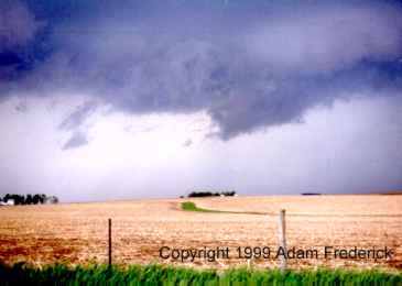 This
is a close-up view of the funnel in Eastern Benton County. We were in
the position that was mentioned in the above severe weather statement.
This area was rotating and was trying to drop to the ground. Every once
in a while, a dust cloud would rise up from the ground. Because they
were such brief touchdowns, I only got the following one on film.
This
is a close-up view of the funnel in Eastern Benton County. We were in
the position that was mentioned in the above severe weather statement.
This area was rotating and was trying to drop to the ground. Every once
in a while, a dust cloud would rise up from the ground. Because they
were such brief touchdowns, I only got the following one on film.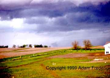
 This
picture was taken in Fairfax facing toward the north at 4:15 PM. At
this point, to have continued chasing this storm we would have had to
drive through a more heavily populated area. At this time we decided
to chase after the storm that had formed to the west.
This
picture was taken in Fairfax facing toward the north at 4:15 PM. At
this point, to have continued chasing this storm we would have had to
drive through a more heavily populated area. At this time we decided
to chase after the storm that had formed to the west.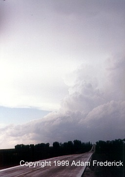 This
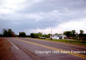
was how the storm looked as we headed back toward Vinton. This was the
second tornadic supercell that moved through Vinton that day. At the
exact same time I took this picture while I was about 15 miles from
Vinton, my parents took the below picture from my backyard.
This
was how the storm looked as we headed back toward Vinton. This was the
second tornadic supercell that moved through Vinton that day. At the
exact same time I took this picture while I was about 15 miles from
Vinton, my parents took the below picture from my backyard.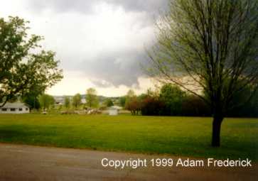 This is a picture of a dissipating wall
cloud. From reports, this cloud at one time was solid. This was the
second wall cloud that day that could be seen from my backyard.
This is a picture of a dissipating wall
cloud. From reports, this cloud at one time was solid. This was the
second wall cloud that day that could be seen from my backyard.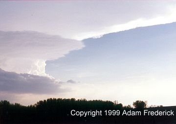 At
the same time I took the above updraft picture, I turned around and
took this picture of the storm we had chased earlier. At this point,
it was dropping baseball sized hail. As shown by the following warning,
it was still tornadic.
At
the same time I took the above updraft picture, I turned around and
took this picture of the storm we had chased earlier. At this point,
it was dropping baseball sized hail. As shown by the following warning,
it was still tornadic.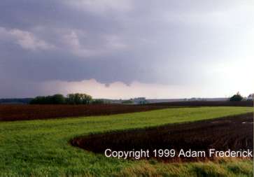 After
this, I continued the chase a little longer but decided to abandon the
chase after being sandwiched between two supercells for over two hours.
After
this, I continued the chase a little longer but decided to abandon the
chase after being sandwiched between two supercells for over two hours.