|
|
Even though it was Easter Sunday, it felt like just another day away at college. So when it looked like there would be storms in Eastern Nebraska, I jumped at the chance to chase them. As we crossed the Missouri river going toward Blair Nebraska, we saw an unusual sight. It was the sight of what could be best described as a low topped, low precipitation supercell. Like most of our successful chases, a warning was issued for the storm as we approached it.
Even though a tornado was reported, we never saw one. There might have been a brief touchdown, but that would have been about it. The storm continued to move across the Missouri river into Iowa. We continued to stay in front of the storm. The storm was rotating nicely and had a very nice beaver tail as seen in the video capture below.
The storm continued to move into Iowa. Like most storms, it hit the Less Hills in Western Iowa and instantly stopped rotating. From there the storm continued to die. For more video captures of this storm, visit the 1998 video captures section in the Photo Gallery. |
||
DISCLAIMER: Remember storm chasing exposes chasers to many hazardous and potentially deadly weather conditions such as lightning, dangerous roads, damaging winds, hail, and flying debris which puts the chaser's life at risk, particularly those who have little or no experience and/or storm structure education. Learning to deal with these is best done by understanding supercells and thunderstorms, and riding with an experienced chaser before attempting to chase on their own. The author of these pages does not encourage storm chasing and is therefore not responsible for any actions as a result of what is seen here! For video or picture sales, questions or comments, please visit our Contact Us page. Pictures and content on this web site, unless otherwise noted, are Copyright 2001 Weather Edge. and may not be reproduced without written consent. For problems, questions or comments regarding this site, please visit our Contact Us page. Web site created by Weather Edge Inc. For your web design needs, please visit http://www.weatheredge.com. |
|||

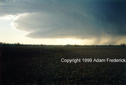 As
we approached the storm, the picture above is what we saw. The storm
itself was only about 25,000 to 30,000 feet in height. The storm was
rotating quickly and was dropping very little precipitation. A small
wall cloud can be seen in the picture above. Shortly after this picture
was taken, the following warning was issued.
As
we approached the storm, the picture above is what we saw. The storm
itself was only about 25,000 to 30,000 feet in height. The storm was
rotating quickly and was dropping very little precipitation. A small
wall cloud can be seen in the picture above. Shortly after this picture
was taken, the following warning was issued.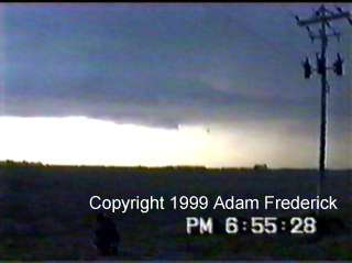 This
video was taken shortly after the warning below was issued for our county.
This
video was taken shortly after the warning below was issued for our county.